
Found out there is also a 100 Coursepoint limit too so might have to put this page on hold until it is sorted. 22 Oct 2008
The 100 Coursepoint issue still hasn’t been resolved which is a pity as it had the opportunity of really opening up the 705. One thing that has come up is where to save your courses. To Save multiple Courses you need to save them to 705:Courses, memory. Do NOT save them to the SD card, it will not be seen.
Ignore the rest of this post as the 100 CoursePoint Limit applies.
27 Apr 09
A lot of you have difficulty with the Garmin 705 100 waypoint limit when planning a Route.
There is another method that uses CoursePoints and you riding a Course.
A Course is a series of TrackPoints and you can have over 17,000 Trackpoints in a 705.
NEW This post is also relavent to the 305 as there is no difference between the two.
You ride the same trackpoints on both devices, just on a 705 you have a map to look at.
You could add the CoursePoints using the TrainingCenter once you have anything better than the PCBasemap loaded. Far easier though is to plan your Course using BikeRouteToaster.
http://www.bikeroutetoaster.com/Course.aspx#save
CoursePoints are the inbuilt Icons in your Garmin but they have been hard to use as TrainingCenter is not a Course planning application.
CoursePoints have similar properties to Waypoints in that they bleep when you arrive at one.
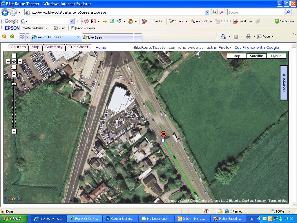
With CoursePoint and AutoRouting selected in BikeRouteToaster you will have the correct turn direction added at every junction. If you tick the coursepoint warning on the summary page your going to get a warning of a turn coming up rather than it being right on the junction.
Just to try it out I went off course and waited for the warning. It came about 50 yards from where the turn was.
You’ve another two screens to view when riding a Course. The Course Data screen has time and distances to the next CoursePoint along with the turn direction Icon so you know which way you are going to turn.

Registering with BikeRouteToaster allows you to save your courses and give a link to it similar to GarminConnect. Save your Course as a TCX file to your documents and put it in the Garmin Course folder on the removable drive.
To ride the Course you need to go into the Training section of the 705 and it will be under Courses. Don’t forget to press start as well or you won’t be logging anything.
Pictures of 705 screens to follow. They will follow when I can get the macro setting on the camera to work so it will be a while . 21 Jul 08.
For planning a Course with CoursePoints as your turn indicators BikeRouteToaster is by far the best out there. It’s a pity Garmin can’t provide decent Route and Course planning software as it is all about making these devices user friendly not user unfriendly.
04 Aug 08 Rode my first Audax as a Course yesterday and it went quite well once I’d remembered to press Start/Stop a couple of mile down the road. For some reason I didn’t get CoursePoints on the second half of the ride but it is definitely the way to go.
There has been another software upgrade for the Edge that gives you a new screen to play with while riding a Course and fixes a few more issues.
Had a comment off Dave F which deals with planning a Course offroad.
Frank,
Now you have suggested saving bikeroutetoaster (BRT) as a course (.tcx) and accessing it through training, I have had much more success off road. I use BRT with autoroute “on” to get me to the start of the offroad section, then using a high scale map (paper or electronic) and switching BRT to satellite view and switching autoroute “off” I can place trackpoints and course points as appropriate to indicate the course on the satellite image – the paths are visible if you look at the map to get the direction. Then once back on road, switch the BRT autoroute back “on”. I hope this makes sense, I previously tried using this method with the .gpx format but I did not find it successful.
This method also works for city centre cycleways that BKR does not know exist!
Thanks for the help.
Dave F
Thanks Dave, the latest Google Maps seem to have a better resolution that now allow planning offroad. You can even see the chairs and tables at the Eureka on the picture above along with the Mini’s at the Mini Centre at the crossroads and all for free.

Hi Frank, I’ve found to make a smaller file tick track points at the top and tick course points at junctions in the auto routing section of BRT. I haven’t rode a ride using this method but when you run the course on the 705 all the turning info is visible.
Hi Frank – went out today on a course with track points ticked and course points at junctions and it worked fine.
Hello Frank, I don’t seem to have a course folder on my device [Edge 705. Can you help? Cheers,
Lee
Lee, open up the Garmin Folder and add a new folder if it isn’t there. If you save a .TCX file there you’ll be able to see it in the 705 under the Training/Courses section.
You can convert some of your History to a Course to ride again.
Frank.
Frank – I just confirmed that the data from the mapping cards for the 705 are transferrable to Garmin Training Centre and Mapsource.
You copy the file ending .img over to the desktop and rename it the same as the .img file in Garmin’s Training Centre program folder. Then rename the GTC one to something else move it to the desktop and drag the replacement (big) file into the same folder. GTC adopts the new map, though it runs a bit slow to show it. It is, after all, 1.4Gbytes.
Chris, Thanks for that. I screwed up my Nuvi until I found out I had renamed the Nuvi .img as PCbasemap.
That was last night and I needed my Nuvi this morning.
I didn’t have the space on the harddrive.
Regards,
Frank.
Hi Frank – I’ve been out on a couple of longer rides and seem to loose course warnings after about 80K!! Similar to the Audax. Also if you want to use a route this site seems good – it’s as fast as Bikeroute but you can do a route on it for GPX navigation.
See you soon.
Joe
I need help. Just started to get into mountain biking, so bought a garmin 705 edge, an topo card for south england an wales, but have got no clue how to use it, i can turn it on , and thats as far as it goes. Can anyone talk me through it?????
Carey
Carey, first of all update the software version. Now 2.4. TrainingCenter now 3.4.3. Go out for a round the block ride, press “Start” and log the ride. When you get back press “Stop”.
Go to History and save this as a Course.
Under Training you can repeat this ride as a Course. You “Do Course”
You should see the Course in pink on your Edge. Follow this Course.
If you go off Course you will get a warning, don’t press enter but get back on Course. It is about 50 yards away.
Know the difference between a Route and a Course.
Try BikeRouteToaster, see DaveF comment in the page above about going offroad.
Press Start on every ride or you will not get any History.
Plan your rides but don’t go overboard at first.
I’ve 8,192 miles on an Edge now, all documented.
Don’t Panic. Very steep learning curve but rewarding once your at the top.
Regards,
Frank.
Frank, thank you very much for your tutorial. I have been struggling with my edge 705 for quite a while and I finally realize how to follow a saved course!. Cheers, Sebastian@Chile.
AS an audax rider how do U use the 705 as an PBP, LEJOG rider as the battery life is only 15 hours , please help Denis
Denis, I’d class myself as a 200km day rider. You could recharge your 705 on LEJOG overnight with a mains charger or a battery pack but for PBP you need to look at a different device. The Etrex devices are being superseded. I was asked by Dave to bring up an AA alkali replacement device.
You can do it on an Audax but PBP is way out of my league.
They tend to stick with the walking devices with replaceable AA cells.
I’ve had feedback about 12 hour charging but that was on a 12 hour race not the likes of PBP.
In conclusion I can’t really recommend it for the serious audaxer as the battery life is too short.
Hi Frank/Denis,
Frank – found your site the other day, the day after buying a 705 – like you say, steep learning curve, but “getting there”, thanks though, great site.
Re power for longer rides – could you use something like a Power Monkey, from Maplin?…2 versions available, one that is just a reserve battery pack, rechargeable and has a whole host of connectors for all sorts of gadgets (phones, iPods, etc)…the more expensive one is the same but adds a solar panel recharger unit for those on long treks without access to mains power (i.e., tape the panel to your helmet! :o) )
Hi Spencer, there is a post about the DIY one I built in the garmin page. There are a few PowerMonkey like chargers out there but Paris-Brest-Paris is 1200km with no time to recharge.
Charging has to be on the bike and this leads to connection and mounting issues.
Ray has an Ahcter one that is put in a bag on the bars.
The step up chargers can charge a USB port device from a 1.5 volt cell but are not too efficient.
Not had a battery problem yet with a 705 but then I’m not riding for 96 hours. Also I haven’t looked at the backlight at night yet.
I’ll try and sort that out in the next week.
Regards,
Frank.
The Powermonkey eXplorer (http://www.maplin.co.uk/Module.aspx?ModuleNo=220936&DOY=30m10)looks like it might be usable for long runs with its included mini solar panel, particularly if you could run 2 on a use 1/charge 1 basis. The battery is nearly twice the capacity of the 605/705 internal one & it should be feasible to fully charge one in a day’s worth of daylight which makes me think you might be able to run this setup almost indefinitely.
Rick.
Rick, £55 rules it out for me and the solar cell only pumps out 200ma max. I’d try the Camelion at £3
http://www.maplin.co.uk/Module.aspx?ModuleNo=222899&&source=14&doy=search#features
Try it with a Duracell and see how it performs. Duracells are available everywhere and this is why the long distance riders like devices that have replaceable batteries.
I carry the Emergency top up battery from them that was by the till for about £2 in the saddle bag. I’ll try the above as the price is right.
Frank.
Hi Frank/Rick – My folks gave me a very similar device to the Chamelion you posted a link to , Frank – however – although great for that “oh c**p!” moment, there is a warning in the instructions that says to only use when the phone battery (in this case) is completely dead, and is not intended for simply topping up a battery (presumably because its not a regulated supply, and would eventually knacker the target battery’s cells?)
I’m guessing you already know that, as the Chamelion probably has similar warnings.
I was chatting this thro with my Brother the other day, who said he’s seen a wind-up charger, a-la the radio that chap invented for the depths of Africa…of course, not practical to charge up a device after a days use, but handy if you get caught out.
[note to self – Google for a modern day, light, efficient and small dynamo!]
Cheers
S
Hi Spencer, the Chamelion took at least one 2000ma/hr battery to put half a charge in the 705. The unit was warm to the touch. It uses a method of DC-DC conversion which allows you to charge a 5volt USB device with a 1.2 volt cell. Google boost buck.
You have to switch your 705 off after it powers up or it powers and charges the 705.
The bag it comes with allows you to charge as you ride. There is just enough clearance on a 705 to run an oversize stem. It would be a problem on a 305.
The wind up charger looked a little bulky.
To be honest I’ve not had a problem yet, 15 hours is about 3 hours more than I’ve been out.
Regards,
Frank.
Hi Frank,
I made a comment or two back in August when I got my 305. Your sites are excellent. I am still learning and have difficulty loading a route from Biketoaster in to my 305. The error message is:
“Course information does not satisfy course restrictions. Please make sure there is enough space in the device for courses, course points and laps.” I have deleted history and waypoints etc but still it will not load. It is a new 100k audax our club are running next sunday and I have saved it at http://bikeroutetoaster.com/Course.aspx?course=24705. The name is ‘Z113ADX’.
Any ideas would be welcomed.
Best Wishes
Andy
Frank,
Ref a couple of comments & your post : “For some reason I didn’t get CoursePoints on the second half of the ride but it is definitely the way to go.”
I have been experimenting with BRT, Tracklogs & BikeHike.co.uk (including e-mailing the author of BikeHike). Coursepoints seem to take up significant memory in my Garmin 205 (and BH’s 305), so I suspect you are exceeding the 100 waypoint limit (or coursepoint equivalent).
For instance, my 205 baulked when thrown a BRT-created 739 trackpoint, ~63 coursepoint autoroute (I have some other courses on the device, too). Mind you, when I removed the “Add Course Point Warnings”, it loaded fine, so the obvious answer is that “coursepoints” are indeed a not-insignificant memory user. I then created a course in Tracklogs with many coursepoints, and when I loaded it on the GPS, only 2 showed …. I saved another copy of it, and none showed.
Conclusions : I almost used up the allowance with the BRT, and the 1st Tracklogs took the rest. No warnings (unless with BRT, by the way, via the Garmin Communicator Plugin). Use them sparingly especially if you want Course Point Warnings.
My preferred method at the moment for a road route is to use a web-based route mapping to autoroute, save/open it in Tracklogs and add my coursepoints (a little ahead of the actual point to give some real-time warning).
Not entirely scientific, but maybe of interest.
Cheers,
Mark
Frank,
I’ve experimented, here’s what I’ve found. Maybe it will help the community.
The Garmin Edge 205/305/605/705 GPS devices all have a “Waypoints/favorites/locations” limit of 100. Waypoints and Coursepoints are basically the same thing; Garmin calls them coursepoints when they are associated with a course.
I used BRT to create a course with approximately 2000 trackpoints and a large number of coursepoints. The course was copied to the GPS via the Garmin Communicator Plugin, which informed me if I exceeded some limit and won’t copy a course. The message is “Course information does not satisfy course restrictions. Please make sure there is enough space in the device for courses, course points and laps.”
The results (for the given number of coursepoints) were :
117 : failed
102 : failed
101 : failed
100 : copied
I then created a 71 trackpoint / 8 coursepoint course, and tried to copy it without deleting the 100 course, but it failed.
Conclusions:
* The 100 waypoint limit applies to coursepoints
* It is highly likely that software which auto-generates coursepoints based on turns will quickly hit the “100 waypoints” limit with the current Garmin Edge GPS devices.
Regards,
Mark
Frank,
After experimenting, I thought this might help others. It applies to the Garmin Edge range 205 to 705 (I believe) ….
Combining Trackpoints & Waypoints (the latter are converted to Garmin Coursepoints) using Tracklogs & a Garmin 205
* Create a TrackLog consisting of trackpoints.
* Add waypoints as required.
Notes :
With the Garmin 205, ensure a waypoint is located exactly over an existing trackpoint. If one is required at the start, place it just a little after the actual start point. Tracklogs is currently (Nov 2008) reviewing its coursepoint implementation for “older” Garmin GPS devices.
To give a warning before arriving at the waypoint, place it slightly before the relevant point on the map.
* Upload the Tracklog to the GPS via Save As Course, and select the Convert Waypoints to Coursepoints option.
From Tracklogs Support : To clear up the confusion with waypoints/coursepoints they are basically the same thing within TrackLogs only Garmin call them coursepoints when they are associated with a course. The fundamental reason for the difference is that the points on a course need to work in the absence of any geographical positioning. That sounds absurd but the Edge’s design does include the ability to follow a course when on a static turbo trainer and it’s this oddity that’s largely responsible for a lot of the complication!
* Check whether the waypoints have converted/uploaded correctly on the 205 via Training/Courses/”my course”/Map. Press the “Enter” button to toggle the waypoint view; flags are used to represent the coursepoints.
This appears to be undocumented, I cannot find any reference to it anywhere.
* Do Course …the little flags that are visible when pre-viewing the course also appear in the main Map.
* The coursepoints appear with a warning beep & descriptive text on the GPS screen as they are reached.
* Some coursepoints off the track (but very close, say < 10m) may also be converted, but can actually distort the track towards them, on the GPS. A waypoint added that was maybe 200m away was not converted (even though Tools/Options/Profile/View/Waypoints to 2000m).
Regards,
Mark
Frank,
Have to commend the site again Frank. I have loaded my 305 with the above Course by following Mark’s suggestion above (very many thanks Mark). Immediacy of internet is great isn’t it. All I have to do now is turn on the 305 and press start. I am not sure if I will get audible warnings but time will tell and I am not far from home so no worries about getting really lost.
Regards
Andy
Mark, thanks for the info. That’s a bit of a blow, I was assured by one of the experts on MotionBased that it wasn’t the case. My 705 stopping giving CoursePoint warnings was due to me showing someone the 705 and stopping the Course at a cafe stop.
I’ll give this a good looking at as riding a Course is going to mean looking at an Edge map all day.
Regards,
Frank.
Frank,
I’ve had some sort of confirmation of this by Tracklogs Support & the author of BikeHike, but all I can say is that’s what I found with the 205. MAybe it’s different with the 705, hope so.
Cheers,
Mark
There’s more ….
I used BRT to create a small route around local roads, with some cross-overs (so maybe not so applicable to a long distance “straight-line” course), with and without “Course Point Warnings”. In practice, I found that WITH them it was often a little confusing, while WITHOUT was (almost) no use at all. Let me explain ….
I set the warnings at 50 ft (which was maybe a bit short). When the 1st warning triggered, it stayed on the Garmin 205’s screen for a while, such that I was unsure whether the 2nd had triggered. There are twice as many map coursepoints copied to the GPS when using this method (ie one for the point, one to warn).
Without the warning, the coursepoint triggered too late (obviously, if one is travelling at any speed).
Also, BRT (and any autorouting application) does not add coursepoints for each and every turn, and sometimes there isn’t one when one would have expected it. That would be like using a sledge hammer to crack a nut. Common sense must prevail here, I’m only looking for a guide at critical points in a route.
The good news : the real benefit comes from the simple fact that BRT applies useful and meaningful icons to the coursepoints, like a bending-left arrow to indicate a left turn. (A straight arrow pointing left would be even clearer …..). So while cycling, I can see a relevant coursepoint approaching and know what to expect. I don’t really need the audible warning or text (which covers part of the screen) for such warnings, but maybe they’re good for informational coursepoints like “Café 200m!!”.
The bad news for BRT : managing the coursepoints in the browser is not as easy as it could be. When autorouting, one can choose NOT to “Add Course Points at Junctions”, then manually insert them to suit one’s taste.
Personally, my preferred solution for road routes (which are done in the dark now, and benefit greatly from coursepoints) is to make Tracklogs my main mapping application. If necessary, routes created in BRT or BH (making use of the wonderful autorouting feature) can quickly supply hundreds of suitable trackpoints for importing into Tracklogs. Manually finishing the course off is a doddle in Tracklogs; waypoints can be added to give warnings and information, and placed a suitable distance before the real point. When the finished course is transferred to the 205 GPS, the waypoints are converted to coursepoints (but note that at present, Tracklogs does not give any indication that the 100 limit has been exceeded).
Please note that Tracklogs Support indicates it is working on improving its coursepoint handling. For instance, the icons are only one type, a flag, so a forewarning is essential. Also, BH is also likely to implement coursepoints in the near future.
I used the above method to lead a relatively complex cycle in the Chiltern Hills, last night; I reckon it saved about half an hour conventional map-reading in a 2¾ ride, gave us much more confidence and allowed me to enjoy the ride, too!
Regards.
Mark
Mark, 50ft is much too short a warning distance. 300ft maybe as the turn is on the junction and doing 20mph you will be on it in seconds.
Waypoints give you the countdown and distance to turn but are as the crow flies. GPS articles in the Comic this week, Garmin 705 coming out top. If only they knew, doesn’t say much for the others.
Frank.
Frank,
50ft : I agree, 200ft is better in real life, but I was almost at walking speed on my Brompton, with a GPS in one hand …. it was an experiment, after all 🙂
What is the “Comic”?
The most important discovery I’ve made when it comes to mapping is Tracklogs, I cannot rate it high enough. It’s made creating cycle journeys an absolute pleasure. The next was the Garmin Edge GPS (a 205 in my case) as we followed its directions in Ashridge forest one dark and wet night while I was using a paper map …. Coursepoints are the icing on the cake; having absolute trust in the OS map and the GPS, allied with some common sense, has transformed my riding experience.
Cheers,
Mark
Mark,
The ‘comic’ is cycling weekly which is in WH Smith on Thursdays. It has a feature on GPS this week (Nov 20) but you are way (and Frank) ahead of them. The article is little more than summary comments on 4 systems. It almost dismisses the 205 and doesnt mention 305 or 605.
I will try Tracklogs at your recommendation and see how I get on.
Regards
Andy
Andy,
Ta for that (and the kind words). 🙂
I have just investigated upgrading from the 205 to the 605/705 (and I’ve only had the 205 for a month!). I decided not to, the 205 does all that I need. And the reason …. Tracklogs. I love OS maps and planning hiking/cycling routes; digitised mapping has been made an absolute joy with Tracklogs. So once I’ve done all the work in it, I only need a GPS that will direct me accordingly. All the other GPS features like real-time autorouting and seeing some form of road map …. nice but not necessary. It takes enough of my concentration to read the 205 on the road, so how I’d read everything else without stopping ….. I’ve even used the 205 in the car, to follow a route I created in Tracklogs.
The application itself is free (so it can be used as a handy converter, trl/gpx/tcx) but to make it worthwhile DOES involve some hard cash. I tend to use the 1:25000 maps (a hangover from all my hiking) as I also off-road.
In practise (as I have just done, tonight) I use BikeHike to do some of the groundwork (using the autorouting for on-road stuff, saves lots of mouse-clicks), maybe in sections, and combine/finish off in Tracklogs. I then add coursepoints as required, print and/or save to GPS. Job done.
The final output can also be uploaded back to BH and saved in the user database; an example (last Tuesday’s evening ride) can be found at http://www.bikehike.co.uk/mapview.php?id=2595 (note that BH does not support coursepoints at present).
Cheers,
Mark
Mark,
Very interesting. I’ve had my 305 since august but am a slow learner. I like it for the training features the on the bike accuracy, and the download record. I have a bit of an affection for mapping but I do not want to carry them or read them on the bike. I have just had a very brief look at Tracklogs. I wonder if you could achieve what you a trying to by getting MemryMap (MM) at 50000 OS scale. I got mine on ebay 2nd hand for about £20. All UK in OS and profiles. OK I not signed up to MM but whilst mine was loaded the other night in the E:drive, and my garmin centre open by connecting the USB on the PC I was able to transfer my audax route (I mean course)(ref:comment19 above) planned and loaded by BRT through the garmin , to display in red on the OS Map 50000 on MMap on screen by using MM ‘import route’command. It even logged position where I (the Garmin) was on the Map a few miles away from the course. I think that in the planning stage for a club run e.g. it will give those who have been brought up with OS maps more confidence at routing through the right junctions etc and is better at showing minor roads and gives contours. I am only mentioning all this as it might provide a cheaper alternative to Tracklogs separate maps. Especially if it is not intended to read them on the bike.
Snow is forecast for our audax tomorrow brrrr!
Cheers and Regards to you Frank,
Andy
Andy,
Tracklogs and Memory Maps are basically the same beast, I believe: digital mapping software using OS maps, with GPS intergration etc etc. Tracklogs UK at 1:50000 is £150 full price (? on eBay?). I have personal experience of the former and I guess MM does the same things. So if you have it at a great price, go for it!
As we are talking about OS maps, and you are familiar with BRT, I’d recommend you look at bikehike.co.uk
Cheers & enjoy the ride!
Mark
Mark,
Thanks for this. My audax went OK if you ignore the persistent rain for the first 4 hours. At least there was no snow or ice.
This was my first time with audible beeps on the Garmin.
The course I pre-loaded worked well but I should have paid heed to Frank about 200 ft prior warnings. On most corners I was 50 yards past, so I was a bit wary and this is my excuse for not getting round as quick as I sometimes can. It was not good at the two complex junctions (zig-zag type cross roads). Nevertheless although I have no basic map on the 305 I can see cafe’s and towns I have already marked, so this gives a good sense of direction. I have had a brief look at BikeHike and can see the sense as it seems to offer both OS map comfort with Google routing in one package. Useful and quicker for pre-planning I should guess, and it could be great if it guides me on XC routes on the MTB. I have not thought the Garmin could do this, but now I think it possible.
Cheers to you and Frank
Andy
Andy,
Glad you had a fairly successful day!!
Fuuny you mention the “complex junctions (zig-zag type cross roads)”. This is what twigged me to coursepoints and warnings in the first place … I was doing a route at night with 2 loops and I ended up doing a loop in reverse, by mistake. The Garmin showed me on the track, no warnings about being “off-course”. I guess I wasn’t, technically : ) just ahead of myself.
So I now go through the route carefully (in Tracklogs), and place the coursepoint/warnings accordingly, making sure that each one is associated with the correct part of the track (it’s easy to get it wrong when 2 tracks lie on top of each other).
And yes, 200ft (I chose about 100m, now) is needed!!
Cheers,
Mark
Thanks for all the input all of you. Finally finally finally getting the hang of this complicated gadget. I usually pick stuff easily with new gadgets but dear god this one was difficult, mainly because of such poor literature supplied with it which leads to misinformation being published on the net (sort it our Garmin, what’s the use in developing a device if you don’t tell the user how to use it properly) , thanks god for the internet and people like Frank.
Just about to get the new toy, so visited BRT to set a few courses for NY. I start at my home, then begin to plot a course but all I get is the same repeated message ‘timeout retrieving route information’. I assume this is a server or traffic issue with the site, but maybe not. I’ve now been trying for appx 15 mins to get something up. Q for existing BRT users, is this a common factor in plotting courses or just a temp glitch. Thnkx.
Hi Graham you need to use FireFox. I had the same issues when wanting to save a Course to the Edge. I run XP on a low spec IBM Thinkpad. It is very common.
Regards,
Frank.
Thanks, got that sorted now. Used BRT for a 70km ride, then uploaded it on to the GPS. However when I go to ‘where to/saved ride’ there is nothing there. Checking on the Garmin Courses folder via the PC the file , a.tcx one, is present. I am though using only the PCbasemap as my Garmin DVD map is coming from a different seller. I asume that explains it and I will have to wait for the City Navigator to arrive.
HNY all.
Graham, you’re looking in the wrong directory. BRT generates a Course and you find it in the Menu/Training/Courses.
Regarding the PCbasemap have Menu/Settings/Routing/Guidance Method set to Off and I would think Recalculate should be off too.
Frank.
There was a reference to a 200 waypoint limit on one of the pages. I’ve tried exporting a 199 waypoint route from Memory Map in GPX format to the Edge and it picks it up fine. If I increase the waypoints beyond 200, I get an erro message when I try to navigate (follow) it.
Now the consensus is a course point is interchangeable with a waypoint and the general beleif being the limit is 100, this might help (a bit).
Bob
Aaaargh! I’m still not sure I fully understand the difference between a route and a course. If a route has an very limited number of waypoints compared to a course isn’t it best to always create a course, for example in BRT? What is the advantage of a route over a course?
Tim,
A Route is an as the crow flies heading to the next Waypoint where you will get a bleep and a countdown to it. It would normally be a turn. You only get 100 waypoints.
A Course is normally a previous riden ride. BRT allows you to plot the Course without having to ride it. It consist of up to 13,000 trackpoints. It is found in the training section of an Edge 305/705.
When riding a Course the only warning you get is when you go off course. A 705 with a map allows you to see what your turn direction will be. Off road thing are much the same between a 305 and a 705.
Autorouting on the likes of BRT makes Courses easy for the road rider. If you like OS maps and planning and can put up with a few twist and turns knowing you’ll get to the turn in the end Routes are just as good if not better in some ways. I started off with Routes.
Regards,
Frank.
Thanks, I think I’m getting there!
Can I try and explain my understanding of how they work?
Suppose I am planning a route that has a particular junction 10 miles north that I want to reach. In order to get to that junction I need to travel 2 miles north, 3 miles east, 2 miles north, 3 miles west and then 6 miles north. I can either:
1. set a waypoint at my target and then navigate myself there bearing in mind that on the second stretch when I am travelling east the heading to the waypoint will be 90 degress from my direction of travel. This would require either knowledge of the roads or a willingness to take twists and turns along unknown roads until you are back on the correct heading or
2. set a waypoint at every junction in between the start and the target and follow the heading to each, i.e. an easterly heading then a northerly heading and so on. This would reach the 100 waypoint limit quicker.
With a route you can go off-course to a certain extent and the Edge will adjust the heading to make sure that you get to your next waypoint even if you don’t take the shortest route, for example, making a tea shop diversion. Therefore, between waypoints you can take any road you like and as lon as you follow the heading you’ll get to the next waypoint. With a course if you take a wrong turning you need to turn round and get back on course because the Edge will only get you to your destination using the pre-determined route.
How’s that?!?
Tim, your not quite there yet. On a Route you don’t want to be doing turns that you’d have to remember. You try to keep the compass arrow pointing in the general direction of travel not 90 degrees to it. A 100 waypoints at 1 a mile is a 100 mile ride.
On a Route you are following trackpoints (or breadcrumbs) and the Compass should always be pointing straight ahead. If you get off course messages you will get another when you are back on course.
Most of the time I’m just logging rides and if anything of interest happened I’d look it up in Training Centre.
Tim, I feel your pain, it has driven me insane constantly scouring the web for clarity, thankfully I found this site. Not sure if this will clarify anything and people feel free correct if I’ve made any mistakes but this is what I wrote down for myself to remember:
A Track or (GPX) file can be created in Mapsource or other online sites like bikeroutetoaster.com. Think of it as a trail of breadcrumbs with hundreds if not thousands of single GPS sample points. It is stored in the Garmin/GPX folder of the unit and tends to be used in conjunction with a purchased map as it will Navigate you from A to B (TomTom style) if you go off course it will then (depending on your preference) navigate you another faster way to your destination as most car gps devices do. In short it has autorouting capabilities.
A course can be either a ride which you have completed and then saved as a course or created again created outside the unit in bikeroutetoaster.com for example. The file (.crs or .tcx) is saved in Garmin/Courses. This file type is usually larger as it can contain other data such heart rate cadence altitude etc. and tends to be most peoples favourite as it is flexible because you can also use software to put turn directions in them. (This is different to navigation) For example: You are creating a course in bikeroutetoaster or similar site and want to be reminded of a good pub someone told you about, when you get to the pubs location (on the website map) you can insert a ‘Course point” (bikeroutetoaster’s terminology, this might change with other sites) and type in ‘Stop here for a pint’. When you are out on your ride and get to that point it will beep and come up on screen what you have typed.
You can also race a virtual partner with these saved courses.
So in a nutshell:
Track (gpx) to get you to a specific location the fastest/shortest way with autorouting capabilities. does not contain user input data
Course (crs tcx) takes you on a journey to get there by a desired non recalculated route. Does contain user input data.
Also, think of a waypoint as a Favourite location. Like a bookmark in internet explorer, it’s not route specific as it’s saved in the device
Hi Frank or anyone who may be able to give me some advice!
My girlfriend bought me a 705 for my birthday. It looks a great piece of kit. However i only have the basemap and am looking for a map of southern England. Preferably 1:25,000 as the OS maps i am used to but 1:50,000 would do. I am a mountain biker and want to plan routes on and off roads on trails etc. What options do i have for the edge 705. Is it only the Garmin map that is compatible or can i buy from anyone else eg Memory map etc. Im looking for the best value map same appearance as the os maps but also i should say my computer i use is an Apple Mac so would the map load on there ok too? Thanks for any advice from anybody as i really cant find info very easily at moment. Regards Lee PS WHAT A GREAT WEB PAGE YOU HAVE. INFORMATIVE ETC. WILL PASS THE WEB ADDRESS TO ALL AT MY CYCLE CLUB
Lee, see the OSM link on Veloriders blog. It is free and the coverage of cycle routes is good. I use it now.
Your not going to get OS map quality on your Edge and Topo GB doesn’t have a scale. The likes of Memory Map and Tracklogs don’t support the Mac.
Have a good look at the Google base websites and have a good look at MotionBased as there are a lot of MountainBike Courses on there. The Redbull runs etc. A lot of these courses are 305 routes which doesn’t have maps.
City Navigator on microSD is popular for your 705 as it covers all of Europe.
The forum is at Motionbased but Garmin do not promote it as they want to close it down.
Regards,
Frank.
Thanks very much for the information Frank. I will look now and let you know how i get on.
Cheers and best regards Lee
Very useful discussion and site, thanks Frank.
I’ve been experimenting with Bike Route Toaster and the autorouting facility and its great when it works. Often however I get the message “Timout retrieving route information” when trying to extend the course. This makes constructing the course very time consuming and cumbersome. Does anyone else get this problem and is this the server being busy ?
Lukas, like it says on the site it works a lot better on FireFox.
I had the same error until I switched over to it.
Sorry Frank if this old ground but I have a new 705 which I am learnings to use.
I have managed to create my own courses from rides I have completed but want to load the route maps from Sportives I am going to do. These are all in GPX format from the websites running the sportives and my saved courses are all TCX files. I really have no clue as to how I get the GPX routes onto the 705 so it recognises them and I can then follow them.
Any help greatly appreciated
Warren, look at the Marengo Route tutorial they are GPX routes.
They reside in WhereTo/Saved Rides. Select Navigate near the start and your on your way. You need to understand the difference a Route and a Course for a start.
Do a simple one first and see how you get on, you shouldn’t get lost on a signed sportive, Audaxes are a different kettle of fish.
Regard,s
Frank.
Thank you for the feedback Frank and as I can get myself lost on a sportive perhaps an Audax is not for me !
Very informative site and much appreciated.
The Edge saves histoy in the TCX file format. I know there are utilities to convert these to other file type and I would like to convert them to ‘tracklogs route files’ (.trt) which would enable me to view them in tracklogs. Has anyone got any experience of these ?
I’ve just installed beta version V.13 of tracklogs which supports TCX files and allows tracks to be saved to the edge 705 as courses. So far seems to work very well. Thanks to Tracklogs support for this.
Frank
Great site. Just got the 705 and am slowly understanding how best to use it.
In May I am touring Ireland (end to end) and have already used BRT to plan the daily routes which use lots of small roads.
Ideally I would wish the unit to give me turn by turn instructions whilst also recording all my fitness and bike data.
Soooo…the dumb questions!
To achive the above, is the best way for me to use it to:
1) Save BTR plots as .gpx and select them as a saved course in “where to” (getting Garmin’s built in warnings which seem to work ok from a test in the car)
2) Press start stop for ever day’s ride.
Will this way ensure I stick to the BTR plots or will it try to recalculate away from it?
Many thanks
Ted
Ted, For Routes I’ve always used Marengo as it has the 100 waypoint limit built into it. Not tried a GPX with BRT. You need to press start/stop every timeyou use the 705 all it does is log your data.
It shouldn’t try to recalculate your Route as all you are doing is navigating to the next waypoint. Which you have named as a turn direction. Sounds like a good ride.
Lukas I’ve updated my version when it came out but not had chance to use it in anger yet. Thanks anyway.
Thanks Frank
Been planning the Irish trip for some time now.
I hadn’t come across Marengo before, I will try to find a blog to see how it works.
It seems not to draw the route in the same way that BRT does, I assume this is to speed things up as BRT can get really sluggish.
Still trying to find the best way of using the 705 for touring. The 100 waypoint limit should be fine for day rides. I will ride out with it this weekend and see!
Best Wishes
Ted
Hello Frank. Here’s a couple of odd things I’d appreciate comment on or if this is something others have experienced.
1) Diligently following the Garmin manual, at the end of a non pre-planned ride I stop the counter, press the lap button to reset and save the data and hey presto, the data is deleted .. this happens every time. The workaround is hitting menu, going into history, into day, then checking the ride has saved. When it has only then can I either switch off or reset the data with the ride being saved.
2) SD card does not read a loaded file. Eg I uploaded the .tcx file for Hell of Ashdown ride onto the Edge itself, reads ok. When I put it into a ‘Course’ folder on the SD, nothing is there. Although I can physically see the course name, both in Courses on the Edge and on the SD through the PC, nothing shows up when I try to see the route/map in the Edge. Any comments gratefully recieved.
Graham, just press Start/Stop I’ve never used the lap button ever I think.
I’m in the same boat regarding a .tcx Course on the SD card. I can’t even see the file on the Edge.
I wondered if anyone else has had the problem I have: My 705 is no longer connecting via USB to my PC. It worked fine on Saturday, then it went abit odd and I had to do a soft reset, and now nothing happens when I plug it in – it doesn’t show as a USB drive. I’ve tried re-installing communicator and the USB drivers, but the driver install gets so far, than asks you to plug the 705 in, and then just sits there and waits.
Help!
Does anyone know if the 705 will accept an 8GB mini SD card? My new 705 works fine but when I insert a (formatted) miniSD card and power on the unit it starts up but never completes the boot. Is there a trick to inserting a new mSD card?
Edward, 2gb max. That is largely wasted too. Don’t bother getting a high speed one too. Keep to 2GB uSD cards and you should be fine.
Hi there. I have a EDGE 705, I am unable (embarrasingly so) to copy a route from the Edge to my computer. I get the details on training center but not on Mapsource.
Frank, great site and loads of great info. I’ve had a 705 for the last 6 months and only really use it to record rides. However, I’d like to start planning routes. I’ve tried to follow the instructions on here using BikeRouteToaster but I’m not getting anywhere. When planning my route I find the mapping software on BikeRouteToaster wants to make up my route for me. For example, If I route across a piece of waste ground or down a small path that isn’t on the map the software takes me from point to point round the roads. I don’t want to be on the road all the time! Is there any way around this. If I turn off Auto Routing then I don’t get the points appearing on the map….it’s just the blue line from start to finish. Does this I don’t have trackpoints or coursepoints or whatever they are called? Really confused!?!
Thanks Gerry, stwitch the auto routing off when you want to cross the waste ground and then turn it back on when you get back on the road. Course Points are the same as Waypoints and are placed at turns. Trackpoints are what you log when you press Start.
If you want to save a Course you should be saving the file as a .TCX course.
Regards,
Frank.
Excellent site and guides Frank!…
Really enjoying using my 705 and getting it setup for a road trip in france for 3 weeks road an track riding… going for courses cus the virtual partner will give me a good pace monitor each day…
I have setup 4 days worth of courses (.tcx files) can copy them onto the 705 but can only ever view the first (day 1 route) if i then delete it i can see the next one down the list but not the others… and so on…
Any suggestions on having multiple .tcx files and being able to view them in advance? (naming convention or somthing?)
I have used BRT to map the routes using course points.
Thanks
David
David, See the 705 page, there is a bit about dragging and dropping the files. Don’t use Mapsource as it appends the files into one temp file. I’ve 18 Courses in there at the moment.
Early on there was a problem getting Courses and GPX files into an Edge as the file transfer was poorly understood.
Regards,
Frank.
Thanks Frank,
Had a rescan and spotted it was the same issue as Dave F comment 221/222 on the 705 page…
Multiple courses only works when they are on the garmin unit itself not the SD card…
could be worth adding a comment on this to the “course guide” page… bound to be others gonna ask the sme thing…
Many thanks
David
A new version of software for the Garmin Edge 705 came out today.
Changes made from version 2.60 to 2.70:
* Improved data recording in once per second mode
* Added ability to set averaging method for power and cadence
* Removed cadence filtering for power meters
* Made improvements to try to prevent spurious Auto Pauses
* Fixed distance and bearing display to work on Saved Rides list
* Fixed issue with trying to read files that start with ‘.’ that caused problems with Mac communication
* Fixed issue where random characters were displayed in list before course names loaded
* Fixed issue with speed targets not working properly in Advanced Workouts
* Fixed occasional issue where a corrupted history file could be created
* Added Venezuela and Australia-Lord Howe Island time zones
* Updated automatic Daylight Saving Time for Auckland, New Zealand, time zone
The garbage names that used to show up in Saved Rides and Courses are gone, however, the distances are still wrong for most rides.
I have been using TCX files to follow courses and it works fine although it is a bit distracting to constantly check the map for my next turn. Apparently what I need are course points in my TCX files. I tried to load a GPX into BRT but it doesn’t seem to add course points to it. When I save a TCX it doesn’t have anything other than regular Trackpoints. Perhaps if I drew the map from scratch it would have course points at the intersections?
I am a bit scared to use GPX files again. The last time I tried it was a total disaster. A 30 mile loop turned into a 3 mile recalculation directly to the end. If you ever take a detour from the course and the Garmin recalculates the route it just sends you straight to the finish. I couldn’t get it to start the course again until I got all the way back to the start!
I found that recalculations are configurable under Routing. The three options are Prompted, Automatic, and Off. I had this set to automatic. Do I need to change this to Prompted / Off in order to successfully use GPX to navigate my loops exactly the way I planned them ahead of time? What is the best way to avoid having the Garmin change the course on me?
TCX always shows the exact course that I planned which is why I prefer to use it but it doesn’t tell me when turns are coming up. If I design them in BRT instead of MapMyRide then maybe it will have these mysterious “course points” and warnings for these course points? I have been unable to get them into my TCX files thus far, however, as I mentioned I have only been importing GPX into BRT and then exporting TCX from BRT.
Ultimately I want the Garmin to navigate me along the exact course that I planned, warning me of upcoming turns. If I deviate from the course I want it to tell me the quickest way to get back on the course, not navigate me straight to the end of the course. I have read most of your site and the comments. Despite the large amount of good information I am still confused.
James thanks for the comment. With BRT you have to select Coursepoints when you start the Course and with Auto selected it will add them at the Junctions for you. Bear in mind you only hace 100 and if you select Warn it will add others before you reach the turn. So your down to 50 turns if you select warn.
A GPX uses Waypoints for the turns, again 100 waypoint limit. This is as the crow flies and you ride it as a Saved Ride and not a Course. With a Route you get a bleep and countdown in seconds and feet to the turn. The compass always points to the next waypoint. Filesize for a Route is about 10kb. Try the Marengo Route planning Tutorial on a short route.
I must have been lucky with my setting as I have never been Auto routed to the finish but I do Avoid Mainroads. BRT shows the Coursepoints as it Autoroutes your ride it can’t generate CoursePoints on a TCX file from a GPX import.(as far as I know) You could always add CoursePoints manually or you could add them to your TCX file in TrainingCenter, it’s a bit tedious but it does work.
BikeHike.co.uk is my new favourite at the moment.
Regards,
Frank.
Thanks Frank, this website is really helpful.
BRT added Coursepoints when I generated the course using the BRT interface rather than importing an existing TCX/GPX file. I commuted to work today using a TCX course that I had generated on BRT. It worked very well, exactly as I had expected from previous experience. There’s only a few dozen course points over the 23 miles.
For the ride home I’m going to try a GPXX file that I just made on BikeHike. For commutes I don’t really care about virtual partners, so I won’t be disappointed if that isn’t supported by GPXX. On the Garmin device it looks as though the course is exactly the way I planned it. If anything goes wrong I still have a TCX course as a backup.
When making routes for commutes do you suggest generating separate routes for each direction or just one round trip route? I have been making separate routes because I fear that the Garmin device will not know which way I want to go. Nearly all of the streets are shared in each direction for this particular commute.
Do you know what triggers the Garmin Edge to start a new activity automatically? I know that holding the lap button resets the timer, but it looks as though the timer reset itself while I was playing with the device this morning after my commute to work (in hindsight, I should have just worked). I would prefer to have each commute as a single activity rather than a separate inbound and outbound ride. It looks as though I will have to merge the XML trackpoints manually to combine them this time.
James, as long as your following the course I don’t think it matters. I’ll have to revisit the GPXX format as it was going off all the time but I had selected every point as a warning. Maybe for the longer rides.
I think the timer adds a lap after 30 minutes stopped. I only ever use start/stop so the lap button never gets used.
Switch it off when you get to work and you should have 2 laps per day.
GPXX is ridden as a Saved Ride while TCX is a Course. They have a similar look and feel but require more investigation otherwise Garmin would be onto them, or perhaps not.
Regards,
Frank.
I used GPXX for the ride home yesterday and it was perfect. This is what I have wanted the whole time. The Garmin flashes turn by turn notices prior to getting to the turn, with the name of the street and a map showing the turn. “Distance to Next” is always the distance to the next turn. The route was navigated exactly the way I planned it on BikeHike.co.uk.
For the multiple laps, I had to combine the sections from each activity into a single TCX file so I could put it on Garmin Connect (http://connect.garmin.com/activity/4734752). The graphs and player don’t appear to be designed for large gaps in time between laps but all the statistics are correct, I double checked that the averages were calculated properly.
I don’t have to stare at the map anymore which makes riding unfamiliar routes much more enjoyable and safer! I can now focus solely on my training metrics.
Ideally, I wanted rides to include the fitness training metrics of a TCX and the navigation of a GPX(X) simultaneously. I think this may be possible. What I noticed was that you can “Do Course” for a training course and “Navigate” a saved ride at the same time. They appear to be turned on and off independently. When I turn both on and toggle the menus using the “mode” button, I see the custom menus for both the course (TCX) and the saved ride (GPXX). I’ll have to test this on my next ride, maybe it is the end all solution to get the best of both worlds with no 100 point limit. I’ll have to save both a GPXX and TCX (without Coursepoints) for the same route, but that is no problem. Fingers crossed…
James, I think GPXX uses the Edge internal routing. You can ride a Saved ride and a Course at the same time, I’ve just not got around to it.
GarminConnect normally plays it all as one file.
Glad to have some feedback on GPXX.
Regards,
Frank.
Tried a 30+mile route (on known roads) yesterday using a GPXX file downloaded from bikehike. I can confirm it uses the internal routing with “turn left onto Scout Road” type instructions with a distance countdown (exactly the same as if you let the unit find its own route).
I did find a couple of oddities, which may have been down to the route I chose (it was a loop with an overlap at the end – I wasn’t going straight home at the end but the 2 ends didn’t actually meet, a bit like a handwritten lower-case ‘e’). About 7 miles in it chirped and the pink line disappeared. On checking the directions screen it was wanting me to make a u-turn & looked like it was routing me direct to the finish. Stopping the navigating and restarting the saved ride sorted that. Then at about 27-28 miles it started trying to recalculate the last few miles to the finish (including wanting to take me up a very bumpy road that is marked no through road – but which you can do on a mountain bike without losing too many fillings!).
I don’t know if the distance between the points you set when plotting the route have an influence but, when I think about it, both places were where there wasn’t much choice of route so my clicks on the map would have been much more spaced out.
Overall though it was much better than trying to follow a course with only off course & the location of the pink line to go on, but I’m glad I was on familiar roads on this occasion. As I say it may be the oddities of the route I used, a more linear route may fare better & it may be that more circular routes are better split into 2 legs so you are always getting further from the start and nearer to the finish.
Rick
Thanks Rick for getting back to me on the GPXX courses. I’m going to have to get out there and give it a go. The Etape ride is a BIG thing with me now so you’ll have to bear with me on specifics.
Frank.
I’ve been using GPXX for loops and it works perfectly. As Rick said it has the same features as internal routing. I changed the re-route option to Prompt so it doesn’t try to route me directly to the end if I leave the route. Now its up to me to plan more routes, the possibilities are endless.
Thanks James, I’ll have to do a bit more experimenting with GPXX courses, thanks for the prompt tip.
Frank.
Thanks James, I’ll try it with the “prompted” setting – mine was on “Automatic” – and see how that does.
Rick
Yes the “prompted” setting works better.
I did the Cycling Plus 100 mile Sportive on 30th May & thought the Edge was still doing odd things – I’d downloaded the route as an (officially linked) GPX from Bikely.com & converted it to a GPXX via bikehike, but found there were several places where my Edge was trying to get me to go a different way to the signs but at least I could tell it to not recalculate & then see when I was back on the same track. When I checked after with my actual route in Training Center next to the Bikely one it was the Bikely one that was out all along!!!
Another update on GPXX routes – I did another (longer) route create with & downloaded from Bikhike. It had the same start & finish that gave me problems before, but this time I put plenty of extra clicks on the route as I created it & this time it gave me no navigation problems. I’m guessing that the extra points is the likely reason for no problems, unless it was the fact I’ve rolled back the firmware to v2.60.
Rick.
That’s good to hear that it worked for you too.
After my morning ride today I got notified that there is a new firmware for the Edge. I am highly concerned about upgrading though… it says ALL user data will be lost, implying that something significant has changed, perhaps even the TCX format itself?? If that is the case I have a feeling that BikeHike and the other sites will not generate files that work. I’m sure I could manually edit the files and update them for the new format (if it did change) but that could be painful. Has anyone tried v2.80 yet?
From Garmin’s website (http://www8.garmin.com/support/download_details.jsp?id=3987):
IMPORTANT: IF UPGRADING FROM A SOFTWARE VERSION LESS THAN 2.80 ALL USER DATA WILL BE CLEARED.
Changes made from version 2.70 to 2.80:
* Restructured activity logging to reduce the number of invalid TCX files.
* Corrected issues from 2.70 that could possibly corrupt the ‘History’ directory.
* Removed potential spikes in the power data after periods of coasting.
* Increased the allowable digits in the ‘vertical to point’ field to 4.
* Increased the allowable digits in the ‘calories’ field to 5.
* Updated translations.
Did a 400km Audax (Irish Mail) a couple of weeks back now and all on one gpxx file. Not a hitch!
PS We need to say it more often, a great resource for 705 newbies and oldies alike. Ta!
Thanks James, I’ve just encountered the corrupt history error with the 705 not uploading my last 2 rides.
Thanks for the info on the 400km Audax thunderthighs. GPXX the way to go for long rides.
James just upgraded to 2.80 and you loose EVERYTHING. I lost 2 rides but I had a problem saving them which hopefully this upgrade will address.
New setting in Data recording. Zero Averaging On/Off.
just upgraded to v2.8, hoping to delete all user data. no such luck!!! still cant delete any of the routes in saved rides. i can delete them from the gpx folder when connected to my pc, but when i disconnect and power up the unit they reappear back in saved rides. unless someone out there can offer some suggsstions soon then im afraid the 705 is heading where it should have gone sometime ago, in the bin!!! im afraid life is far too short to keep going around in cicles trying to sort this thing out. frustrated, james.
Hopefully Frank won’t mind me trying to answer James’ query!
James, try deleting the rides out of your Edge when it is connected to your PC, but here’s the important bit – Make sure you empty the trash bin on your PC too. For some reason, the Edge has a lingering relationship with the trash bin and the only way to get ride of the rides data is to empty it!
Hope it works for you.
Dave.
I should have added, empty the trash bin before you disconnect the Edge.
hi dave, thanks for the advice, will give it a try and let you know the outcome! cheers,james.
There’s a new “james” on here now, hey james. Just wanted you to know I’ve been the with the capital J ;). Still haven’t upgraded to 2.8, scared.
Hi Frank,
Just bought a edge 705 and not being very technologically minded I’m finding it tricky to understand the downloads and transfering to the gps unit. I have the Navigator SD card and with it comes a warning to not use it to transfer Mapsource data? I have to admit to not knowing what this means! I’ve used bikeroute link you suggested to map a route and added to the gps Unit ok. However I want to be sure I don’t overwrite the SD card. Any help appreciated!
thanks
Hi Caroline, If you bought the DVD version of Navigator you have to transfer the map into the 705 using MapInstall or MapSource. The first thing MapSource does is delete the map on your Edge. As you’ve an SD card map your going to be fine.
You could when your adventourous copy the map to your PC and replace the PCbasemap in TrainingCenter but get to grips with the 705 first.
Regards,
Frank.
Thanks for the advice Dave.
hi James, re comment 92,
sorry for the confusion, my frustration made me overlook the obvious!!!! from now on i’ll refer to myself as james#2,:). regards 2.8 i’ve had no problem using bikehike,tcx and gpxx seem to download and navigate fine so far, and i’ve been able to upload to training center without any dramas. i only wish i could delete them from “saved rides” when i’ve finished with them!!
james#2.
hi dave, re comments 89 & 90,
tried your advice but alas no joy, a case of close but no cigar!! i deleted the gpx subfolder in garmin folder in the edge, emptied recycle bin and disconnected the edge. when i turned the edge back on and went to saved rides, “no rides saved” came up, YIPEEE!!, or so i thought. when i reconnected edge back to my computer and went back to garmin folder, the gpx and current subfolders had reappeared complete with gpx file, BOO HOO!!. i disconnected edge from computer and called up “saved rides” and all the rides i’m trying to delete were back. i think its a case of going back to scratch, i’m going to delete gpx subfolder, empty trash bin, and disconnect the edge. i’m then going to uninstall all the garmin software on the computer and redownload it all again from the garmin site. fingers crossed, i’ll keep you posted!
james#2.
Thanks James! I’ll upgrade to 2.8 today and give it a go.
Wow – this is a great thread!
I plan to use my 705 to navigate a known bicycle path/course on a 7 day trip, and have created a .GPX file with trackpoints for each day’s ride using Bikely. Knowing of the 100 global Waypoint and 100 global Coursepoint limits, and desiring prompting at turns, I’m thinking that my best bet is to:
a) Create 7 .GPX files, one for each day, containing only gpxx extension records (convert using BikeHike)
This gives me the turn-prompting I want, without exceeding CoursePoint/warning > 100 limits.
b) Separately, create a single .GPX file containing only Waypoints for all destinations and truly
significant POIs along the way for the entire week (still < 100 total)
c) Load all 8 .GPX files (7 with gpxx, 1 with Waypoints) into the 705.
Result is that I see my route highlighted, get turn prompting, and have destination and other key Waypoints loaded in case something goes sour, and don’t exceed any 100 CoursePoint or Waypoint limits.
Would any of you set this up differently? Does it also make sense to have .TCX files without too many Coursepoints as a backup (in addition to my paper maps :-)?
Thanks,
ChuckB
PS: Would like to hear other opinions on whether gpxx is “reliable” enough to use for this purpose, or whether I should use .tcx courses instead? Last weekend I rode a gpxx course, and a major sub-section in the middle of my route that *seemed* to have missing routepoint gpxx’s when loaded into the 705 (showed direct offroad between points).
There doesn’t seem to be any tools to spot-check a gpxx route — if you try to load with Mapsource or BikeHike.co.uk, it only shows the direct line between start and end. Yeah, I can overview the highlighted route using the 705 tiny screen and joystick, but that would be painful for 7 days of riding :-).
ChuckB
ChuckB, Tcx is only going to alert you if you go off Course. which means looking at the screen a lot. A gpxx route is going to alert you of the important turns you need to make.
I’ve not done enough rides to make an informed decision.
Frank.
Hi, can somebody help me please? I have Garmin Edge 705 and following problem: i dont see any .tcx files on both usb devices after connecting garmin to my pc, so i can’t download any data to Sport tracks software. On Garmin itself I can see my tracks. How to transfer tracks to PC? Thanks.
Hi, Save your ride as a Course from the 705, this stops you loosing the data.
If you upgrade to 2.80 you will loose all your History.
You should have a History folder in the Garmin folder. If you haven’t create one. I had the same problem as I didn’t have a History folder for some reason.
The .TCX files are stored there.
Regards,
Frank.
Been following this site for a year or so since I got my 705 and it’s superb. Garmin UK telephone help line is very good, but only open office hours, so this site is mustard.
Did the excellent Anthony Maynard Sportive arranged by Reading CC today. Downloaded the route in GPX format from their site (link hopefully attached) onto my 705. This is the only the second time I’ve used it for navigational purposes. Everything worked perfectly until about a third of the way round at Wantage when the instruction do a U turn came up. This carried on for the rest of the ride, together with numerous other messages trying to send me off course.
I think the device had decided to reverse the course. I was riding with two other guys who have 705s and they said they had experienced exactly the same problem on other rides ie it reverses to course/route. I also experienced it first time I used it to navigate but assumed I must have hit reverse course in Tracklogs by mistake.
Any thoughts anyone?
Sorry about the gpx problems on The AM, as it was one of mine, I hope that was not the reason – Oh and glad you like the ride. We have raised over £6000 for charities.
I have been using gpx and gpxx files for a while now with no problems. One issue I did have (like yourselves) was with gpx routes re-directing me on circular routes, ala audax/sportive type circuits. I was alerted to the ‘Routing’ ‘Recalculate’ needing to be ‘off’ and since then ‘saved rides’ has worked fine – where the Edge now sticks to the track rather than using it as a ‘guide’, given that it knows where I am trying to get to and then trying to get me there faster!!
kolemjdoucí – On Sporttracks, have you upgraded to the latest software? I had similar problems, previously having to import tcx files exported (right click) from the Training Center software, until a month or so ago when the Setup_SportTracks_2.1.3478.exe update came out. Since then sweet as a nut!
When in map mode and following a route on the push bike along a road, the unit keeps telling me to head east, head north east, head north, head east……. this sounds good, but it is a road with some bends in it. I only want it to either show me the next junction i.e. where I have to turn left, or for it to tell me to turn left in x yards.
This is really frustrating. Anybody know how I can get it to stop saying east, north etc etc as I travel down a single bendy road?
I brought a 605 a couple of months ago ready for my trip to the italian
lakes in the middle of august, seem to be getting on well with it but was
just wondering if the city navigator map from the Sd card can be used
in the Garmin training Centre so I can see the rides with a bit more info,
or is there any other software I can use for this.
Also found a good site http://www.ridewithgps.com, to create routes and download
gpx or tcx files and upload your rides.
And just one last thing can you search other users rides on bikeroutetoaster.
and thanks for a great site
To resolve the North, East, West & South routine you need a suitably detailed base map so that your track can ‘anchor’ to it and directions will then become left along xxx road, etc. The basic Garmin map will generally not be sufficient. Try:
http://www.mapomatic.net/garmin-maps-download/
for a suitable map download and instructions for installation onto your Edge.
Paul, you can copy it across and rename it as the pcbasemap, see Daves site. It’s a big file, 2 GB so make sure you have plenty of space on the hard drive.
Pete it sounds like a setting issue, a coursepoint or GPX point will give you the warning. Are you riding a pre planned route or just an Edge generated found place?
Thunderthighs:
I have the GB TOPO v2 map installed. This shows contour lines, footpaths, tracks etc.
I use the default mapsource software to plan my routes and it is fine to use with only one annoying thing in that you only get a little window to view the detailed map instead of the whole screen.
Frank, all:
Re: messages 98&99 above, I used by 705 on our bike trip. Again, this was 1 week of mostly off-road bike paths, in addition to small town streets.
Conclusion is that gpxx was too buggy for this purpose – same problem as described in #99 where on rare occasions the waypoints get replaced with line-of-sight. I reverted to tcx which was totally reliable.
ChuckB
When people are saying that upgrading to 2.80 deletes all user data, is this just the rides or is all the bike profile data (ie odometers etc) deleted also? If I’ve just downloaded all my history to Training Centre is it then safe to load 2.80?
Odometers get reset, profile lost along with unsaved history. The problem I had with 2.7 was I lost a ride I really needed the data off as it wouldn’t save. The original problem was that the history folder was lost.
Hi Frank
When you say the odometer gets reset is that just the “history” one that gets reset if you delete your history or do the cumulative ones in the bike profiles survive (that have been permanent for me up to now through updates & roll-backs – despite warnings that all data would be lost!)?
RE ChuckB’s comment (#111) about GPXX being buggy, I think rather than that it is a case of it having limited ability to route when not on ‘navigable’ roads & will simply show compass directions. With Bikehike it is probably best to add a liberal dose of fixed via points (Control-click in drag edit mode) in off road sections. In fact it is probably a good idea to add them with on road routes that take very minor roads as the Garmin routing may not pick quite the route you want.
I did one of the Peak Audax midweek rides this week and there was one (short) section where my GPXX route (created from the downloadable GPX via bikehike) varied from the instructions. Comparing routes afterwards, there were 2 possible route between waypoints with the instructions going one way & the GPXX file trying to send me the other.
There was another (again short) section where the downloadable GPX was wrong/out-of-date – but that is a completely different issue, I just need to check the route more carefully before commiting it to GPXX!
Rick.
Hi Frank
have been following your site for a while as I knew I’d need some help when I got my 305 – which was last week !
I’m using BRT to create courses.
But I’m still abit confused as to how I create a ‘route’ (as opposed to course). I can create a course in BRT and download it ok – but presumably that BRT ‘course’ still has a 100 cousepoint limit. When I use the automated link facility it donwloads the course to the folder.
So how do I create a ‘route’ in BRT ?
Does BRT just create courses (with the inherent 100 course point limit ?).
Cheers
Steve
Hi Steve,
You can’t create a Route in BRT only a Course with Coursepoints.A Course can have 13000 trackpoints.
Use Marengo to create a Route of Waypoints(100). Marengo won’t let you enter more than 100 so you can’t go wrong. Its saved as a GPX file.
Courses are .TCX format.
Routes are .GPX format.
There is a big difference in file size with a GPX file being only about 10Kb long.
Routes are a better option on a 305 as it has no map and you Navigate from Waypoint to Waypoint.
Regards,
Frank.
Hi Frank
thanks for the reply.
So courses have a 100 course point limit, and routes have a 100 waypoint limit.
Sorry – next Q…….so why are Routes (via Marengo) better in a 305 if they both have a 100 ‘turn pointer’ limit ?
I’m not sure a 100 course or waypoint limit is enough on say a 300k audax.
I noticed in BRT that if I checked the warning box (to give warning ‘X’ amount of distance before the turn) this created double the amount of course points. So presumably one can dispance with the actual turn coursepoint if the warning is used ?
Is this the same in Marengo ?
Sorry for being a pain ! Your repleis may be helpful to others.
Cheers once again
Steve
Steve,
Routes have a 100 waypoint limit.
You can try riding a Course with no CoursePoints, this would be a saved ride from TrainingCentre but you would have no turn indication.
This is the problem when riding a new Course that you haven’t ridden.
A 300k audax is going to give you battery life problems as you are going to need a recharge and 100 waypoints may not be enough.
BRT adds the warning points before the turn when autorouting as it need to work out which CoursePoint Icon to use. You’d have to manually delete it. I haven’t tried GPXX with Bikehike yet on a 305.
I rode the Wild Wales yesterday as a Course on a 705 with no CoursePoints with most of the time spent on the map.
With Marengo using Waypoints you are naming the Waypoint as the turn direction. At a roundabout it could be 3Xl (third exit left) Marengo relies on you placing the Waypoint at the junction or just before it for increased warning.
You can manually add CoursePoints to a Saved ride in Training Centre but you need a decent Garmin map.
The 100 coursepoint limit is stifling both devices.
Regards,
Frank.
Thunderthighs
re your comment 104 in response to my 103 and AM ride, your route worked brilliantly until exiting Wantage. No idea what happened after that.
For us novices, could you tell us exactly how you created this route/course or whatever it was ie what software did you use, what sort of files did you create (eg if you used something like Tracklogs then I think you need to save it in one file format then recreate into another format before transferring to the Garmin?), was it a route or a course, how did you create the alerts about upcoming turns/junctions? So step-by-step instructions would be really useful as the result was absolutely superb.
Many thanks and hope not too demanding a question. I’m getting really frustrated with my 705 as in over a year I’ve yet to successfully navigate a route with it!
Paul. All of my routes were created on bikehike, exported as gpxx files and loaded on to my 705. After that is was navigate saved ride but recalculate is off. I have also tried overlaying this with a course file, coloured differently just to act as a back up, the gpxx has worked fine to date – although I bow to the “off road” guys who are obviously having issues when using them in this way.
Many thanks Thunderthighs.
Interestingly, I have just put the phone down to the excellent Garmin Support team in the UK. The guy explained that the 705 navigates the same way as a car sat nav. So, even though you have plotted a route, if it thinks there is a more efficient route it will recalculate and send you that way.
He suggested that I use the Map My Ride website to plot the route. Then save it as a gpx track and transfer it to the unit. As you pointed out in your 4 August post, in Settings-Routing turn Recalculate to “Off”. Also in the same screen, set Guidance Method to “Off Road” even though you may be riding on road.
We shall see!
Well, I’ve successfully navigated my first route which I plotted in Bikehike and transferred to my 705 as a gpxx file.
It took me all the way from the bottom of my drive to the start (and end) point at the top of my drive – all of 100 yards. Unfortunately that is where it ended, having missed out the remaining 59 miles! It presumably decided this was a far more efficient route.
Trouble is, pretty much all of my routes and courses start and finish at the top of my drive. Which may explain why I’ve never managed to get my 705 to navigate me anywhere??
Maybe I’ll give up on the navigation aspects and trade it in for the new Garmin 500!
Paul
I have had similar but found that going a short distance then stopping & restarting the navigation seemed to sort it out.
One way to force a gpxx route created in bikehike to take you further is to go into Drag Edit Mode and add a few via points (using CTRL+click) at the extremities of the route. It can be worth adding them to force the route onto minor roads where there is a similar, possibly marginally more direct route on busier roads.
Using the above I’ve found the routing works pretty well although one thing I have noticed a few times is that now and again for a short section the route, instead of following the road, tries to take a straight line to the next point. It may be doing this more often but is only really noticeable when you are following a particularly windy stretch of road. I’m not sure of the cause but my hunch is that it is either I was adding too many via points to try to force the route exactly where I wanted it, the roads on Google maps don’t line up in places with the Garmin maps so the 605/705 assumes you are going off-road or, quite possibly, a combination of both.
Rick
Thanks Rick. I’ll give that a go. Or get a longer drive.
Thanks Rick, stopping and finishing at the same point has been problem since the 305 days. Most of my recent problems have been in the planning phase but for the last 2 events I’ve relied on other peoples courses with no coursepoints or waypoints.
I got around OK but most if not all the ride was on map mode and it doesn’t like you going off course.
Great site Frank. Very useful for the Edge owner ! Firmware up to V3.1 as of December, not been much traffic on here since September. I recently bought a 705 Edge, also had various other Garmin sat-nav products for a lot of years, started with GPS II+.
After trawling through everything on here I think I`m up to speed on how to use the Edge and what sodtware to use it with.
Routing with BikeRouteToaster, upload to unit as .TCX file. Settings – “routing”, “recalculate” to OFF. Seems to be working OK with turn-by-turn messages (didn`t get this with BikeHike and .GPXX files when I tried it), need to get out and try it in anger rather than round the block!
Thanks John, a lot of people are using the 705 now. You can tell by the number of Garmin bleeps at the eureka Cafe.
I’ll be taking a look at the mapping upgrades in the near future.
Garmin Connect is far far better than it started out as, it’s just a pity Garmin don’t do any routing software.
Regards,
Frank.
Considering getting the 705, but would like to clear a few things up first:
1. Courses/Coursepoints
– If you create a course in BikeHike, with course-points added for turns, the maximum is 100 points right….
SO…If you have a course with 100 course-points points saved on the device, does this mean that you will be unable to store any further courses/course-points on the device as you have reached the maximum the device can take?
WHEN RIDING A COURSE WITH COURSE-POINTS does the device do the following: highlight the route on the map, show your position on the route, prompt you to turn on screen/with sound?
Are you able to follow a course whilst the device simultaneously logs your speed, HR, cadence and position?
2. Routes:
As I understand, routes are simply as the crow flies waypoints (max 100), which prompt you to turn when you come near to them. Does this mean that you DONT see a highlighted route on the screen of the device, only a plain map?
3. GPXX:
If i want to go on a ride I have never done before how would I utilize GPXX to achieve the following using Bikehike:
– Turn by turn prompts
– Highlighted route on the devices map
4. Finally:
Whats a track and how does it differ from a course?
Thanks,
J Parkin
There are three riders in my regular ride (4th joining), with 605 or 705’s and just like when mobile phones suddenly got popular, everone has the same “ringtone”. It’s now getting irritating, everyone beeping at the same time.
At the cafe stop, I take mine off the bike and switch it off otherwise it beeps as it tries to find a satellite link.
Hi all
a note about generating “course point warnings” in BRT that may be useful to others.
Whilst the distance at which a warning is placed before the actual turn depends on personal preference, specifying a large distance often leads to erroneous routes.
If the the distance between 2 “regular” course points is smaller than the specified warning distance (e.g. when navigating through short streets) BRT is unable to place the warning. Instead, it will bend the route sideways in a triangular fashion (and not locked on roads) to forefully place a warning course point.
This is annoying during the ride as it is hard to navigate with constant “off course” warnings.
Hope this helps
I’ve used courses (tcx) files from several sites and definitely prefer courses for cycling. None of the sites use the Notes field in the Course Point data structure. Does anyone know if this field will be displayed on a 705 together with the turn icon?
I’m considering doing some post processing of the tcx xml file to insert additional information, but won’t do so unless this field will be displayed.
Rick I’m not sure if this isn’t used to give you the route(course) directions. The crux of Routes is naming the waypoint as the turn direction.
Frank,
Another note/question related to tcx files. I’ve found on my 705 that only 28 course points are displayed on the map and the route sheet. I haven’t ridden any of these many-turn courses yet, but I’m hoping this is just a case of the 705 buffering the displayed course points. The tcx file, itself, is fine and contains the correct number of CPs correctly located. Any thoughts?
I had the same question that James Parkin had:
“SO…If you have a course with 100 course-points points saved on the device, does this mean that you will be unable to store any further courses/course-points on the device as you have reached the maximum the device can take?”
Also, I’ve set my Garmin to warn me several hundred feet (~200) before junctions, but the garmin often misjudges junctions i.e. I am at the junction waiting to turn but it tells me that I have another 50 feet to go to the junction (course point). This means that the warning comes kinda late. I created my course on BRT. Any idea why that might be happening?
Matt, I think it is 100 Coursepoints per Course not as 100 total Waypoints for all your Routes.
It depends on your warning setting on BRT, it uses up an extra Course point to give you the warning. It also auto places the Coursepoint on the turn itself. Try letting it autoroute more turns as if you place your Coursepoint at the junction the software doesn’t know which way you are going to go next and might give you a wrong turn direction. I’ve seen it once or twice. Place the point after the turn and the warning should be OK.
Ok, I am a little confused about the difference between Track points and Course point.
Do you plan a course (using BRT) with Track Points but then add Course points manually to give you the ‘turn icons’?
And Question 2 – do you always use tcx as opposed to GPX?
Hi Matt, you can have up to 17,000 trackpoints in a 705 so this is a long ride. If you have a device with a map then this is no problem. Coursepoints are handy if you require turn directions on say a 305 or Forerunner device.
On a Course(tcx) your never likely to be more than 30 meters off it.
GPX is more point to point navigation.
If you have all the bells and whistles you may as well use them.
GarminConnect also uses TCX format.
Regards,
Frank.
Ok, so I have a 705 with the Garmin City Nav map. So I will create tcx files on BRT but will not get ‘turn by turn’ – is that about it?
(that should have finished with the following) – unless I create specific Course Points at junctions, etc?
Hi There
I’m new to Garmin Edge and would like to thank Frank for this invaluable forum. I’ve been reading the posts on here and experimenting for a couple of weeks now.
It seems to me that there are two main ways to use the Edge for navigating a pre-determined route:
1 .tcx files. Can be uploaded from BRT or Bikehike. These can be used for navigation but only prompt you when there are course points present. 100 course point limit applies.
2 .gpxx files. Can be uploaded from bikehike. These contain data that allow the unit’s navigational ability to calculate the route and prompt for turns etc. Provided that settings-routing-recalculate is’off’, then the route you see in bikehike is the route the Edge will take you on. There is no need for course points, so no 100 point limit.
To follow an uploaded .tcx course, go to menu-training-courses.
To follow an uploaded .gpxx course, go to menu-where To?-Saved Rides
Thats right Matt, plain TCX is just a Course. Coursepoints are supposed to be added in TrainingCentre which is hard work by any ones standards using a Garmin map.
Thanks Patrick, a site update is required but I don’t know when it’s coming. By the time I get around to it a new Edge will be out.
Hi there, don’t know if you can help with this issue. I created a course on bike route toaster. Loaded it onto my 705 as a tcx. Rode the course and want to upload it from my 705 history onto Garmin Connect. Connect cannot read the file. I’ve tried uploading from my PC and that doesn’t work either. The file in the history folder on the 705 doesn’t have a date or time – it just says “toaster course”. If I connect the 705 to my PC and look at the file it appears to be the same as all the other files in the history folder. Any ideas?
Cheers
Simon
Sorry for the delay, had a similar problem training for the Etape and ended up loosing all my history. Save the ride as a Course on the 705 that way you won’t loose it if you have to do a Hard reset.
The ride should be saved to history when you plug in the USB port. Make sure you are not missing a folder like I was after a software update.
Regards,
Frank.
Fabulous, what a website it is! This website provides helpful facts to us, keep it up.
I have purchased an Edge 510 on a trade in program after learning that my Edge 305 has a software defect that Garmin will not correct since the device is no longer being made. When following a course on the Edge 305 and at the same time using the Virtual Partner, the Edge 305 uses the elapsed time as the goal time. The elapsed time includes all pauses. For the Virtual Partner to be effective the goal time should be the running time or the time without pauses. This means, in the words of the Garmin rep, that “your virtual partner [is] unusable.”